The Hydrographic Service maintains a network of permanent sea level recorders (tide gauges at ports in Greece’s maritime space to monitor changes to sea level). The stations enable the analog recording of any change to sea level, round the clock. The data are also recorded digitally (through ten-minute or fifteen-minute sampling) at selected stations and in the context of network upgrading, which enables phone transmission of the data in virtually real time. Also, the recordings of four stations (Piraeus, Katakolo, Syros and Kalamata) are directly available on the internet through the HS website.
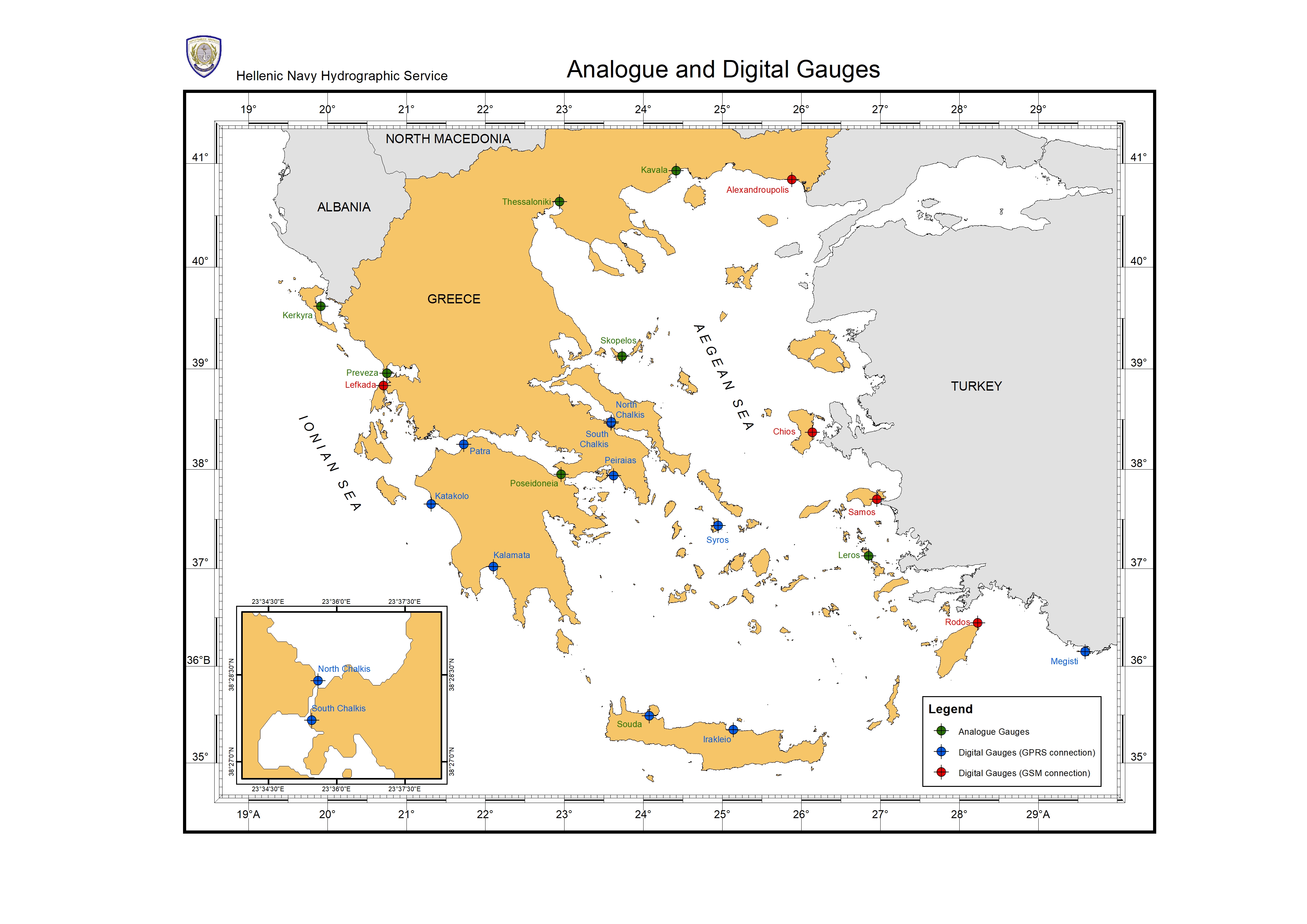
In the future, all analog sea level recorders will be gradually replaced by electronic ones, which will be equipped with atmospheric pressure, temperature, salinity sensors and GPS. This is expected to reduce losses and upgrade the quality of observations by extracting direct data indicating how atmospheric (inverse barometer effect), thermosteric (rise of sea temperature), allosteric (changes in salinity) effects, and coastline movements (earthquakes, shifts of the crust of the earth) affect the level of the sea.
Sea level data in the form of hourly values are collected, processed and archived, while statistical information is also drawn about sea level in 23 areas of the Greek maritime space, in the form of monthly and annual statistics. The stations of the existing network provide the statistical data for the period from the 1990’s to date. These data have been compiled and issued (together with a local leveling network, area charts, etc) in the study “Statistical Data of Sea Level at Greek Ports” and are available for activities including:
Works in maritime cities : management of rainwater, sewage channels, etc.
Port works : port construction and deepening.
Commercial ports: safe sailing of ships, loading and unloading of goods.
Ship repair zones : lifting and lowering of vessels in repair and maintenance docks.
Provision of certified measurements to the scientific community for research.
CIVIL PROTECTION – Alert systems for hazardous and disastrous phenomena: alerts and forecasts of hazards owing to extreme weather conditions (extreme waves – meteorological tides) or to submarine geological phenomena (earthquakes – displacements – shifts of plates which could result in seismic waves -tsunami).
In the context of its participation in national and European programs aiming to develop and upgrade the network, the HS has participated or is currently taking part, through the Oceanography Directorate, in:
a) The ESEAS Program (European Sea Level Service- Research Infrastructure), 2002-2005
b) Memorandum of Cooperation between the HS/HN and the Dionysos Satellite Center of the National Technical University of Athens (NTUA), relating to the installation of four (4) sea level recorders and GPS stations in areas of national and surveying interest. In the context of this cooperation, the first integrated metering station was installed on the island of Megisti (Kastelorizo).
c) Climate Cosmos Program (Development of National Infrastructure and a National Web Portal in relation to Climate Change in Greece, following the Scientific and Technical Guidance of the United Nations and the Global Climatic Observation System,2013-2015) with the participation of the National Center for Sustainable Development (NCSD), the Institute of Geology and Mineral Exploration (IGME), the Hellenic National Meteorological Service, the 'Athena' Research and Innovation Center in Information, Communication and Knowledge Technologies


