HNHS compiles the official Electronic Navigational Charts (ENCs) of Greece in compliance with the S-57 Ed 3.1 standard of the International Hydrographic Organization - IHO. These charts are intended for professional Electronic Chart Display Information Systems (ECDIS). ENCs for ECDIS are made available encrypted with IHO S-63 standard. They can be used by any other non-ECDIS system that can read S-63 encrypted S57 Ed. 3.1 data (ECS systems).
The Greek ENCs are made available to the market since April 2004. In all these years HNHS has gained significant experience in the design and compilation of ENCs, a fact that is recognized by the marine market worldwide. Until today, HNHS has built in total 311 ENCs covering areas that fall under the country’s cartographic responsibility. At the same time, HNHS provides a monthly ongoing Updating Service.
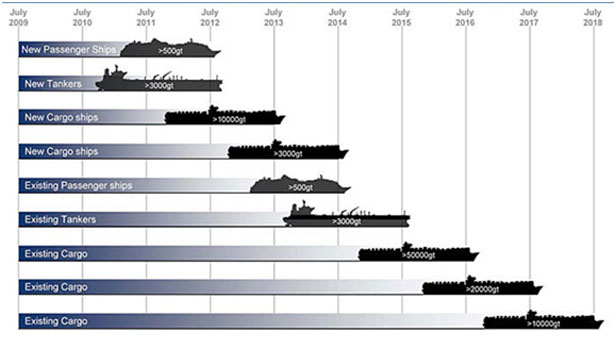
By decision of the International Maritime Organization (IMO), ECDIS, powered by ENCs, will replace printed nautical charts in SOLAS vessel categories in accordance with the following time schedule:
Greek ENCs are made available in the market via the Regional ENC Coordinating Center IC-ENC and its VARs (Value Added Resellers) and distribution network.


